CALL WALLS - The Game- In full Swing!
Calling all Historians and general lovers of History and Prehistory! Now is the time to share all your primary sources, evidence and first hand accounts you’ve found which references “Stone Structures and Walls” built after 1492 by the newcomers to the North East. The game of Call Walls is now in full swing! The Game is designed to call the hand of those who claim their were no stone walls before the arrival of the Europeans and/Or that the indigenous North Eastern people left the “stones untouched.”(Robert Thorson’s belief)
Any historical evidence of stone work built post-contact (after 1492) will be subtracted from the 252,000 miles they tallied and counted during the 1871 US agricultural fence census. Diary entries, Survey maps made before and after the walls were built, Prints or paintings that show the settlers actually building the walls will be accepted. .
Otherwise- we will consider the stonework as “Pre-existing”. Sorry “negative evidence” will not be considered.
Thank you in advance for your input, participation and historical references!
Speak up or forever hold your peace!
These are the Walls we are looking for!
Let’s keep turning on a new Paradigm!
Matt Bua-
****No need to respond if you are not able to find any historical evidence of walls or dry stacked stone structures being built in historic times- Neither could Susan Alport or Robert Thorson! (except for the Asa Sheldon reference below). By the way - Susan Alport commented in her book that the energy that went into building all the stone walls in the North East was equal to building the Egyptian pyramids 20 times over!
From Susan Allport’s 1994 book ‘Sermon in Stone’
“I hoped and expected to find letters or diaries of at least one or two articulate wall builders with firsthand descriptions of what it was like to turn New England’s confused mass of rocks and trees into fields and fences, to repair the same recalcitrant wall year after year. With all the walls- and therefore all the wall builders- that had once existed, this expectation did not seem unreasonable, though I knew it would require some searching. Yet I succeeded in turning up very little first hand material, material that would give some idea of the flavor of this back breaking task”
Susan Allport could find only one scant first hand account herself which she included in her book - while scratching her head over not finding any others- Asa Sheldon “a farmer, trader, and working man who was born 1788 and died 1870”(Yankee Drover: Being the Unpretending Life of Asa Sheldon, Farmer, Trader, and Working Man, 1788-1870)
Robert Thorson- Author of Stone By Stone - found no primary or historical sources himself and borrowed the Asa Sheldon reference from Susan Allports book. One single reference between the both of them ?
So let’s be generous– and say Asa built 10 miles in his lifetime—---- Ok- Great.
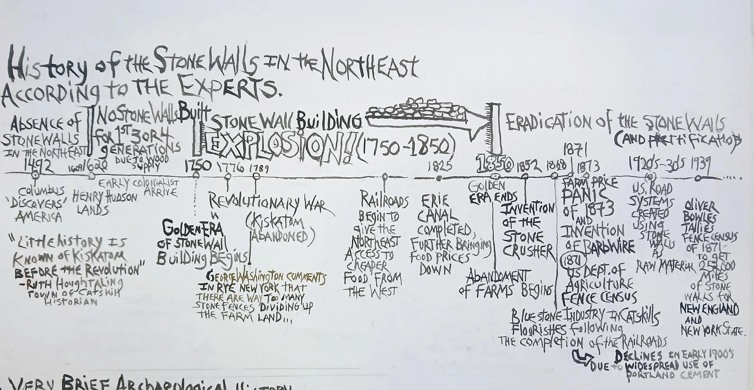
So the ‘Call Walls Game’ tally as of 3-3-2025 is:
Pre-exisiting Stone walls of indigenous origins-
251,990 miles
Stone walls built Post Contact = 10 miles
New Tools for Tallying!
2 sites for LIDAR- one is for the whole United States. The second is for just New York.
New YorK Lidar:
Now that some decent LIDAR imaging is available for the United States- we finally have a tool to see and tally up, with more accuracy, the amount of stone walls and running “heaps” we have in the North East. With the measuring tool included as a feature to the New York site. Go to the Hill Shade imagery-tab and to the right is the measuring tool.
Again- I propose we call the game “Call Walls” where everyone starts counting up their walls and stonework and if no historical evidence is available that might point to a “post contact” construction— The walls will go into the “Pre-existing” tally. Many grey areas exist- such as when ‘old’ walls are cleaned up and ‘prettified’ in historic times. Even Robert Thorson agrees: Those who got the stones to the site and did the initial building- did most of the work. .
“Budcat7” in his shaky but clear- youtube video series “debunking mainstream history of the Stone Walls” looks a little closer at the infamous 1872 agricultural fence census data and finds that it would of taken 15,000 men a staggering 659 years to build all the stone walls- (since they generally didn’t work on Sundays or during the winter months)
https://www.youtube.com/watch?v=-O-eAB6Qenw&t=840s
Also- Let’s face it- The ‘Fence Viewers’ (Allport’s name for the 1871 wall and fence census data collectors ) who were traveling around the northeast tallying ‘stone fences’ were most likely just counting the walls near farms and settlements and they probably weren't going deep into woods where no one lived - thus leaving out all those endless walls that still criss-cross the land “basically in the middle of nowhere”- from their final 252,000 mile tally. I predict that once we figure out a system for tallying the walls, the miles of existing stone walls in the North East will be at least triple- 750,000 miles. Looking forward to finding out!
“Come walk with me, and I will tell
What I have read in this scroll of stone;
I will spell out this writing on hill and meadow.
This is New England's entablature of rock,
Leagues upon leagues of sealed history awaiting an interpreter…”
Tiny excerpt from Helen Keller 1904 poem: "The Song of the Stone Wall"

“The walls have many things to tell me,
And the days are long. I come and listen;
My hand is upon the stones, and the tale I fain would hear
Is of the men who built the walls,
And of the God who made the stones and the workers.”

The Great Lithic Catskill Reveal
More about Hopeskillian Culture here
Open letter to all Historians, Pre-historians, Geologists, and all lovers of the great mysteries of the past
“We ascended the hill through a rock cut and walked over the backbone of the ridge. Ten steps furnished evidence enough that here beneath our feet was the most remarkable archeological monument in the state of New York. It was literally a mountain of arrowheads!” -Arthur Coswell Parker from The Great Algonquin Flint Mines (Coxsackie, NY) 1925 Page 109
Good tidings!
I hope this note finds you well in these curious times. I’ve posed a challenge to myself - and in turn, I am need of your help to either prove or disprove a claim I am making.
The claim: The western part of the town of Catskill, and down into Ulster County, contains “The Worlds Largest Ancient Bluestone Quarried Reservoir System.”
As some of you know, I wrote a book entitled: ”Talking Walls: Casting Out the Post - Contact Stone Wall Building Myth in the North East.”
Since the book was released in 2015, I am proud to say, no one has successfully refuted my research and the conclusions that my book comes to:
Many of the stone walls and stone structures (stone cairns, vaults, chambers, dams, wells, etc) we see all around us today are indeed of indigenous origins.
Today I write you asking for help - not with the more contested “who built the stone wall” debate - but a larger issue: who built the, mindboggling, large scale, ancient reservoir system that runs the 30 plus miles from lovely Leeds in Catskill, down through Harvey Fite’s Opus 40, and beyond?
I propose that this lithic earth sculpting project is as large – if not larger - than the famed Hohokam canal system that Jack Swilling discovered etched into the dry landscape when he first arrived in Snake Town, later renamed Phoenix, Arizona in 1867.
Some Historic Quarrying Background Basics
The quarrying industry for our area was very brief.
According to Michael Kuddish's book "Catskill Forest: A History," the quarrying industry flourished after the trains were built, and, then, it declined rapidly after the invention of Portland Cement in the early 1900's.
Kuddish notes that “because the quarries were often small, most were well under an acre, they occupied a small percentage of the area of the Catskills.” In general 3- 10 men were employed 6-8 months a year for the purpose of whacking away at stones that they sent down to New York City for sidewalks and other things. They were not making the giant reservoirs that run from at least Leeds, NY, down through Kiskatom, Quarryville and Opus 40. Utmost respect to those folks before us who created this hydraulic marvel!
When I brought up my project to a local geologist, recently, he asked if I was aware of the New York State Museum’s 1901 Bulletin #61 “Quarries of Bluestone and Other Sandstone in the Upper Devonian of New York State,” by H.T. Dickens.
I was pleased to say that this bulletin helped to support my research because it noted that near the still operating quarries, there were “a number of abandoned openings that had not been worked for several years.” There are no more details, but the open-ended nature of this statement leads one to wonder how many abandoned openings did Dickens observe, and how many years had it been since they had been worked on.
Also, the map included in this bulletin denotes in my area of study - sites of Quarries “no longer in operation”.
How do we know these reservoirs have been made by human hands?
• The shapes. Many right angles can be noted in the aerial photos. These are not naturally occurring shapes from some type of erosion process. A truism goes something like “There are no right angles in nature ---with the exception of crystals.”
• The amount of stone removed, while quarrying out the reservoirs, is often still present on the east side of the reservoirs. Large organized roadways, ramps, raised platforms, etc, are clearly still intact.
• The stone-built surfaces and structures are made with roughly quarried stone, with no metal tool marks present.
*Though one does find near these sites clear evidence from the brief historic quarrying industry… this evidence is only in very small concentrated areas.
A quick summary of the issues and problems surrounding the Euro-centric Stone Wall building storyline
People have been living under a false assumption that the unfathomable amount of built stone work in the North East was completely constructed post contact by the European new comers in less than 200 years. A rough tally of stone walls using government agricultural data from the 1870’s came up with something like 252,000 miles of walls!
This was supposedly after they used all of the trees for the much easier rail fences - 3 or 4 generations in - and prior to the mass farming exodus that began after the market panic of 1819. This exodus continued in 1825 after the completion of the Erie Canal, and soon after-the further opening up of the west after the train system was created. By the panic of 1837- New York wheat prices plummeted 70%. [i]
In the early 1700’s when the Plymouth and Virginia Colonies had something like 65,000 people each, we are told by Roland Van Zandt in his book “Chronicle of the Hudson” that upstate New York lagged behind with around 20,000 inhabitants. For upstate New York to have something like 95,000 miles of stone walls tallied (that’s 38 times as long as I-40 that runs across America!), with a very low population, is highly unlikely.
Also, we can’t forget the various wars and conflicts fought in the early days of our country, as well as the harsh winters that froze the ground. Both made stone quarrying and stone building activities much harder to carry on.
The Hard To Come By Historical Evidence
Any researcher who’s looked into these gigantic lithic mysteries can tell you that the primary sources and firsthand historical accounts of Europeans actually describing the building of these endless stone works are very hard to come by. Just ask stone wall authorities like Robert M. Thorson who wrote “Stone by Stone: The Magnificent History in New England’s Stone Walls” or Susan Allport, author of “Sermon in Stone”.
***This is where I really need your help as historians. As you comb our local histories please alert me to any references to the construction or destruction of the old stone work.
The Argument for Indigenous Origins to the Reservoirs-
If an ice-free Upstate New York was accessible 10,000 years ago[ii], isn’t it more plausible that the Indigenous People who lived here before us - and who had something like 9,600 extra years to have worked together - created this?!
I stand by the idea that we are, in fact, talking about an amazing, communal, sacred, act of arranging and sculpting their landscape in collaboration with Mother Earth, to benefit their whole community by creating reservoirs to hold and manage water. This idea is totally in line with current theories of archaeology from across the globe. In fact, even Christopher Columbus immediately took note of the advanced water canal system that the natives had constructed in present day Haiti[iii].
And if our local indigenous population was capable of making a mountain of arrowhead and flint tools at the Paleolithic flint mine in Coxsackie - why then could they have not made this reservoir system?
This is clearly the most logical answer. I strongly encourage everyone who’s interest is piqued by this prospect, to visit any one of the sites that are included in the areas I am including in this world record event.
In conclusion….
Could this collection of massively sculpted bluestone reservoirs have been made during Greene County’s “2,000 missing years” that the late great New York State Archaeologist Emeritus Robert E. Funk referenced in his 2004 book “AN ICE AGE QUARRY-WORKSHOP The West Athens Hill Site Revisited”?
“Where might additional Paleoindian sites be found in Greene County? The available data shows that sites, and isolated finds of fluted points, occur in much the same places as subsequent Archaic peoples. In other words, they are all over the landscape. Some Paleoindian sites including quarry-workshops might be found west of the Helderberg Escarpment, where there are a number of small quarry-workshops of largely unknown cultural provenience. … It seems clear that in the absence of an effective predictive model of site locations, new Paleoindian sites may only be discovered by extensive coverage of Greene County on foot.…Almost certainly, the area of Greene County was never completely depopulated after the close of the Paleoindian era. The same goes for the rest of the Northeast. But there are 2,000 “missing years” in the extant archaeological record of Greene County” (my bold) pg.129-130
The time is NOW to announce to the world that Greene and Ulster County’s Indigenous population - from the period prior to European contact - has created arguably the worlds largest quarry and reservoir system in the world, or at least in America.
My sincerest gratitude –
“Let not even a drop of rain water go to the sea without benefiting man” -The words of Parakrama Bahu I (1153-1186 c.e) concerning the purpose and determination in the construction of the Sri Lankan Irrigation Systems.
Please excuse any errors in my research, so many of these sites need to be field checked and studied more closely. I am working to follow the threads where they lead me. We’re just scratching the surface here --- As Lennon and McCartney sang “The deeper you go – the higher you fly,” and as Fred Allen Wolf said “The real trick to life is not to be in the know, but to be in the mystery”
Thank you for taking the time to read this letter and responding accordingly. Your wisdom, knowledge and input is very important to the success of this project.
For maps and more images- please go to
https://www.b-homebuild.com/new-page-1
-Matt Bua. October 2021
[i] Some of this timeline info is from Robert Thorson’s. book , Stone By Stone, page 165
[ii] A quick google search: “The most recent glacial advance covered nearly all of New York State about 20,000 years ago. When the climate turned warmer, the glacier gradually melted back to the north, leaving even the St. Lawrence Valley free of ice by about 10,000 years ago. ”
[iii] This reference is from the book: The Early Spanish Main :Carl Sauer’s Classic Account of the Land, Nature and People Columbus Encountered in the Americas
***“This project is made possible with funds from the Decentralization Program, a regrant program of the New York State Council on the Arts with the support of the Governor and the New York State Legislature and administered in Greene County by the Greene County Council on the Arts dba CREATE Council for Resources to Enrich the Arts, Technology & Education. “

Thank you Albert Flores for Mapping Technical assistance!

Ancient Reservoir Spotlight #1- Combining USGS Aerial maps with field checked documentation- one gets a sense of the scope and breath of this mind boggling endeavor.

Collage of one of the reservoirs in this line-
The Graduation Cap and the Shaft of Dreams

Eastern ‘Face’ of the Impressive Stone work- with shaft opening noted
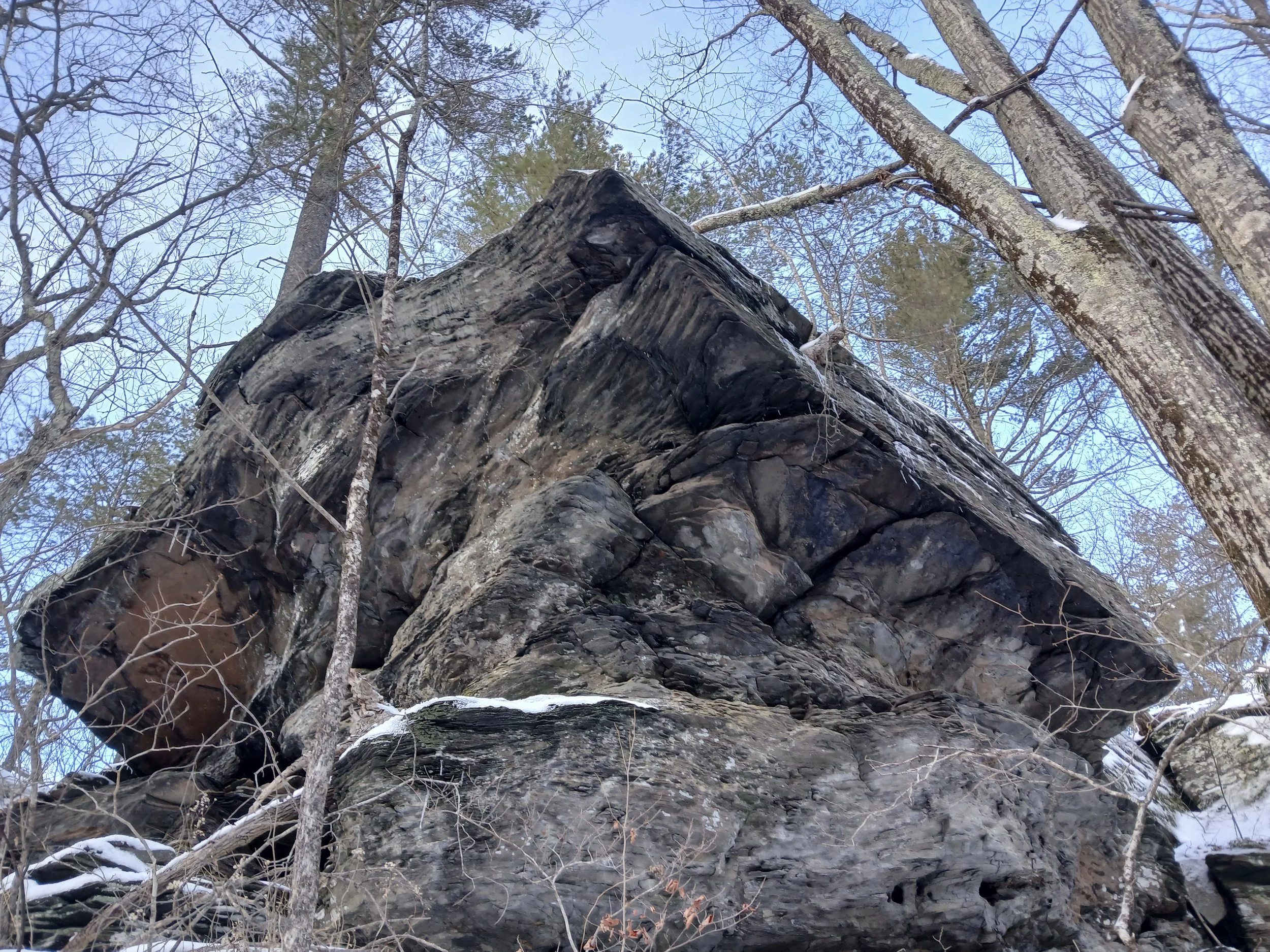
The “Graduation Cap’ in all its splendor!

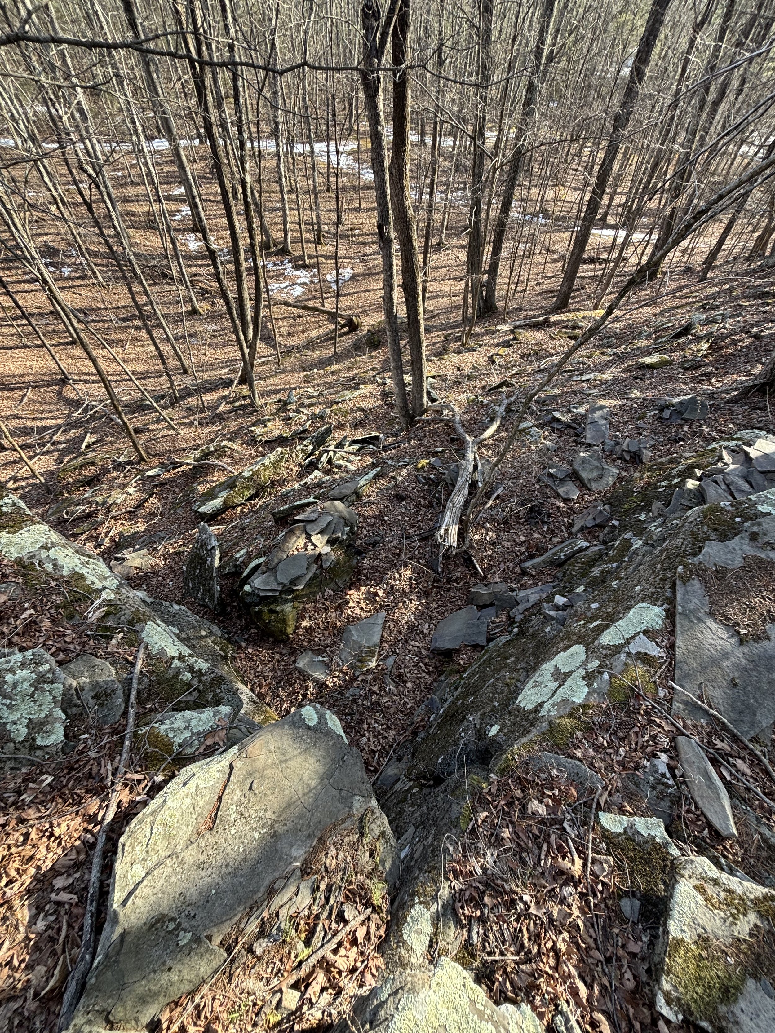
Head in- Look east and be amazed!

Here’s where you lay head down - and look through the shaft

When looking through this long carved shaft looking east through the cliff- an impressive human profile is revealed!?!?! (There is a second shaft carved that has a different angle of sight. (more soon)

A possible second “face” appears as you look through the second shaft—
Is pareidolia really such a ‘bad’ thing?
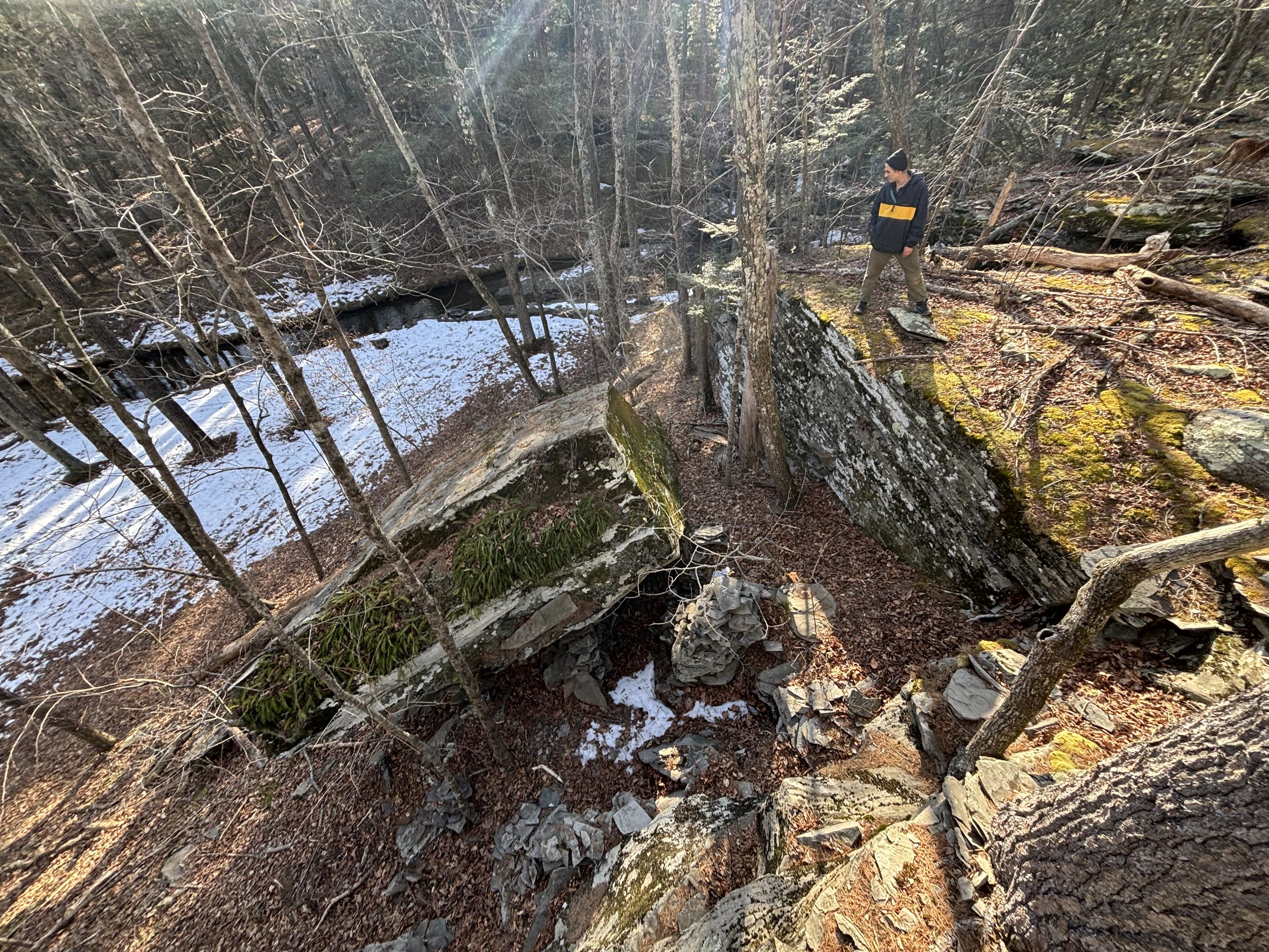
Ancient stone work in relation to the waterways

Note the 'cloud serpents' with their zig zag designs and looks like possible stone work to help direct the flow of water....This definitely seems to relate to all of the stone work along the waterways and the quarried zig- zag canals we have around Catskill (image to the right)) above image found in LeRoy H. Appleton,’s : American Indian Design and Decoration, Dover 1950

Stone work helping to create the bend in creak-view looking north- They say- ‘Water with more bends and turns has more “chi”’ and energy- That’s why- You should go ‘chasing water falls’ Negative Ion goodness- Gracious!

Same stone work- looking south- Blue lines drawn to emphasize the little island that is potentially the result of the built stonework.- You really have to see it in person to fully appreciate it.

From the book: Talking Walls p.56-
Giant megalithic quarried blocks in Catskill NY- connected with Site in UTAH!?!
whether it’s a completely “natural” breaking down process or not- When the removed blocks end up positioned next to each other 150 yards away- or they’re missing completely- It’s pretty impressive!

Lidar Image from this site showing the “cliff cuts” on the left and the red lines are where it looks like two of the massive blocks that were removed- ended up, across the road at b-home!!!! Pictured below

Big Ninety degree wedge #1 quarried from across the road - removed from the ‘cliff cut’ (looking west)

Wedge #2- Looking East
90 degree Wedge with the removed stone nowhere to be found!?!? Photo: Gavin Barker

A page from Talking Walls showing what I call the Cliff Cuts where some of the huge quarried blocks got moved across the road and rest at b-home.
Below are some images taken from this You Tube video which deals with an analogous site in Utah which shows similar quarried stone works..
And this one

Note the built stone terrace. in the upper left- This is all tied into the 30 mile plus reservoir system mapped above.
Giant Wedge with removed 90 degree Mega Stone. photo: Gavin Barker
and over in Utah!


images from you tube Video:This Ancient MEGA QUARRY Discovered In Utah Changes Everything and this one. Lots of revelatory discoveries abound…

And in Egypt….

"Nobodies Fault”

Carved out web work/ honey combed goodness- A still from a quick pan from the video: I discovered Impossible Geometry on Google Earth- Note the Carved out rock at the 17:20 min mark
and the ‘Sacred Living Rock’ Site!?!
Here in Catskill we have our own version of this- and then some!


Some Other Related Research Below

‘Official’ Turtle Head Effigy with Specific Magnetic Properties confirmed… Author was “permitted one sentence of speculation to wit” in his 1976 Nature article.
Which was: “Might the carver have come to associate the uncanny homing instinct of turtles with magnetism?”

Thank you Magpie books in Catskill!

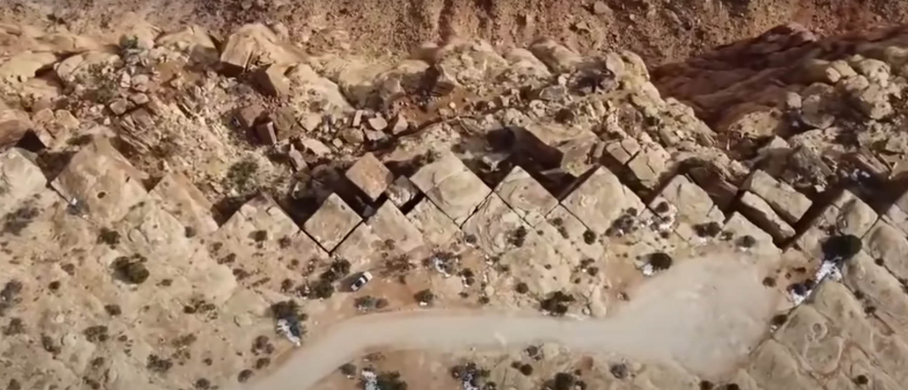
‘Old’ Stone Walls of the American South West…. look familiar?


Nice image of the mapped walls- from the Hudson Valley Farmscape Ecology Program in Columbia County- Thanks Christian Sweningsen for that lead! Hopefully they have any historical info about their origins. I would take a quick guess and say that’s about 30 miles of “walls”. In the Image below the lower green arrow is pointing at an interesting looking enclosure(blue line). and a possible Cairn field underneath the top right green arrow (red circle). Looking forward to field checking this!
Notes and these 2 images from the Hawthorne Valley Farmscape Ecology Program- “This is zoomed into the area where most of the Rheinstrom Hill trails are. The green arrows are pointing to stone walls, can you see the somewhat obscured one in the top right corner? Sometimes the walls and fields are well-defined and geometric, while other times they are alone, floating in the middle of a hill where there is a level enough spot. These places were probably grazed rather than used as cropland. The orange arrows are pointing to fields with plow lines visible on the surface. Can you see the different plow directions in these two fields? The purple arrows point to the ancient forest patches, where there is more microtopography and rock outcrops.”


C’mon! Let’s Face It!


The Turtle is Laughing “Good- Bye, Good Bye!”


The Monkey Man!


Monkey Man’s eyes and nose

And Monkey Man- looking west


chert creature

Advent Man Head! He’s BIG!

looks like a nice fellow…

Lots O New York Effigies! From the book Talking Walls


“Birdee in the plan- for Life’s rich demand”- R.E.M.


Crocodile/ bird- like rock and poodle- note the vein of quartz for the crock’s mouth-
image from Here

Found HERE

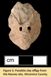


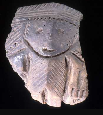
From the NY State Museum collection

A wall continues on behind me in the direction this triangular slab is pointing.


The Kiss of Life


Little yellow and red bic pen in the nostril area for scale
endless research! Connecticut stone chambers——

From a Mike Luoma Article on Medium- of an impressive boulder arrangement in Pennsylvania Notice the carved out mini cave areas across the “Face”

Muir checking out this giant petrified effigy boulder— The Eyes Have it!


For Upstate New York to have built something like 95,000 miles of stone walls (that’s the length of I-40 across the country 38 times!) with such a low population- and little or no historical evidence?!!?